Sunday, August 13, 2006
Beacon Tarn, Coniston
Jess and I found a hidden jewel in the Lake District fells this week - Beacon Tarn, on the edge of Lake Coniston, tucks itself quite snugly in a dip behind Beacon Fell.
We found a fairly moderate route from Coniston Lake, which starts with a pleasant climb through a valley to the tarn itself, followed by a circular walk round the tarn, a climb up Beacon fell with it's own panoramic views of Lake Coniston with a final descent to the starting point.
The whole walk can be completed in approximately 1.5 hours, climbs about 215m and is 4.5 km in length.
1. Start this walk from the Brown Howe Car Park, just by Lake Coniston on the A5084
2. Turn left out of the car park for a short distance, turning right across a small bridge over a brook. Follow this narrow road for just under 1.5 miles to a point where there is a small wooded area behind a stone wall on your right at the top end of a farmers field. At this point there is a path through a bracken-covered area on your left. Follow this path.
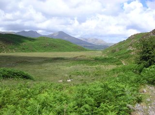
3. Where the path splits, keep to the right and follow the path up the hill through the bracken. Looking backwards you will be able to see the Coniston fells, including the aptly named Coniston Old Man.
4. Continue along the path which runs along the left-hand-side of the valley. The path becomes stoney underfoot and should be approached with some caution - there is a small tarn on the right-hand-side. Eventually you will climb into a narrow gap at the end of the valley where you should be able to glimpse the beauty of Beacon Tarn in the dip below.
5. Descend into the tarn and follow the path down it's right-hand-side. There are plenty of potential picnic places at various points around the tarn, which should be take advantage of if the weather.
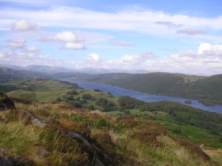
6. At the southern end of the tarn follow the path up Beacon Fell. At the summit of the hill you will be able to see Lake Coniston on your right which covers a vast expanse up and down the valley.
7. Past the summit, follow the path down the hill bearing left on all occasions dropping down the the roadside you originally walked up. Follow the road down the hill to the starting point.
GPS co-ordinates:
Waypoint Position Elev Course Distance
WP10 SD 28290 91490 97 m 224°T 28.2 m
WP02 SD 28270 91470 99 m 255°T 277 m
WP03 SD 28000 91405 118 m 269°T 139 m
WP04 SD 27860 91405 119 m 179°T 49.9 m
WP05 SD 27860 91355 126 m 243°T 172 m
WP06 SD 27705 91280 139 m 191°T 265 m
WP07 SD 27650 91020 171 m 190°T 315 m
WP08 SD 27590 90710 182 m 185°T 90.4 m
WP09 SD 27580 90620 194 m 279°T 86 m
WP10 SD 27495 90635 172 m 192°T 328 m
WP11 SD 27420 90315 169 m 204°T 281 m
WP12 SD 27300 90060 167 m 173°T 110 m
WP13 SD 27310 89950 169 m 179°T 30 m
WP14 SD 27310 89920 172 m 096°T 40.2 m
WP15 SD 27350 89915 167 m 170°T 65.7 m
WP16 SD 27360 89850 169 m 142°T 49.9 m
WP17 SD 27390 89810 170 m 092°T 79.9 m
WP18 SD 27470 89805 167 m 017°T 63.1 m
WP19 SD 27490 89865 165 m 020°T 80.6 m
WP20 SD 27520 89940 166 m 017°T 232 m
WP21 SD 27595 90160 197 m 018°T 308 m
WP22 SD 27700 90450 222 m 026°T 241 m
WP23 SD 27810 90665 250 m 029°T 302 m
WP24 SD 27965 90925 188 m 028°T 121 m
WP25 SD 28025 91030 172 m 012°T 133 m
WP26 SD 28055 91160 150 m 022°T 136 m
WP27 SD 28110 91285 136 m 041°T 155 m
WP28 SD 28215 91400 109 m 037°T 88.8 m
WP02 SD 28270 91470 99 m


